Komotini

© Rhodopean · CC BY-SA 4.0
The capital of Thrace, and one of the most multicultural cities in Greece — a university town of coffeehouses, minarets and neoclassical mansions, standing on the plain where the Roman Via Egnatia crossed northern Greece.
Key facts
- Komotini is a Greek city, in the region of Thrace.
- Best windows: April to May and September to October.
- Busiest period: July to August — peak season, highest prices and biggest crowds.
The story of Komotini
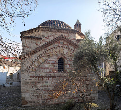
Komotini is not the Greece most visitors come for, which is precisely why it is worth the detour. It sits on the northern edge of the Thracian plain, far from any island, and it has the particular density of a real working city: a university, a market, a mosque beside a church, and a river mostly noticed through the bridges over it. The old quarter is best walked late in the afternoon, when the light comes in low from the Rhodopes behind the town and the streets begin to smell of roasted chickpeas and freshly ground coffee. The Imaret stands near the castle wall, older than almost anything else to be seen in Greece, and it is startling to find an early Ottoman soup kitchen in the middle of a living Greek city. Down in the square the clock tower keeps time for everyone. Komotini has a large Muslim population whose families were exempted from the exchange of populations in 1923, and that is felt in the fabric rather than read about: the call to prayer and the church bells overlap without either being a performance. It is a university town — the Democritus University of Thrace has its seat here — and in term time there are students everywhere, which gives a provincial capital an unusual energy.
History
Komotini’s story runs straight through a Roman road. The Via Egnatia crossed the plain here, and a small rectilinear fortress stood beside it, raised by the emperor Theodosius I in the 4th century AD to hold the route west. An inscription on the surviving wall reads “Theodosiou Ktisma” — the building of Theodosius — and the square plan of the castle still looks more like a Roman camp than a medieval one. In Byzantine times the town was called Koumoutzena, a fortified station on the same road, though for much of its early life it was overshadowed by the larger city of Mosynopolis to the west. The Ottomans took it in the early 1360s, and Gazi Evrenos Bey made it his first seat, building the Imaret — a soup kitchen for the poor — and the Old Mosque almost at once. The Turkish name Gümülcine derives from the Greek. Under Ottoman rule the city grew into a genuine regional centre, its prosperity resting on tobacco, on grain, and on roasted chickpeas, which were famous well beyond Thrace. In the nineteenth century a clock tower went up and the railway reached the city, and the mansions that line the centre date from those prosperous decades. Komotini was occupied by Bulgarian forces during the Second Balkan War and ceded to Bulgaria at Bucharest, and its Greek inhabitants were driven out. Greek refugees from Asia Minor settled here after 1922, while the Muslim population, exempt under the Treaty of Lausanne, stayed. Today it is the capital of East Macedonia and Thrace, a university city of some 52,000 people in a municipality of 65,000, and one of the most genuinely mixed towns in the country.
What to see and do in Komotini
- The Imaret built by Gazi Evrenos Bey in the 1360s, one of the oldest Ottoman monuments in the Balkans and among the earliest examples of its type anywhere
- The Byzantine castle a small square fortress from the time of Theodosius I, its 472 metres of wall running through the streets of the old town
- The Yeni Mosque the only building in Greece carrying İznik tiles from the 1580s, the high point of the İznik potters’ art
- The Clock Tower raised in 1884 over the main square, and the city’s meeting point
- The old market and its confectioners the other title Komotini holds is capital of sweets, and soutzouk loukoum is the thing to buy
- The Kompsatos river and its bridges the stream running under the city, diverted outside the walls in the 1960s
- The Nymphaia forest, six kilometres north-east trails, a further Byzantine fortress, and the wartime fort of 1943
Things to book in Komotini
Booking · these are affiliate links · we may earn a commission, at no extra cost to you
Around the area
Komotini sits roughly thirty kilometres inland, and the water is close even so. The Thracian coast at Fanari and Agia Paraskevi lies about thirty-five kilometres south, under an hour by car, and Lake Vistonida with its lagoons and fishing villages is nearer still at around twenty-seven kilometres. Beyond that the regional unit is worth a couple of days of its own. Imeros Gorge, where the Arda has cut a passage so narrow that the road passes between cliffs almost at touching distance, is the most dramatic hour you can spend near here, and the road to it runs through country that barely changes. At Agia Paraskevi, an hour south, stands the ancient theatre of Maroneia, which a summer festival fills with music — Maroneia gave this city its name as the seat of its metropolitan. The Nestos crosses the county to the north with its reservoir and its wooded banks, and the lagoons around Vistonida hold flamingos in spring. Higher up, the mountain villages above Maroneia and Imeros speak Greek, Turkish and Slavic in the same street, and the evenings are long and slow.
What to eat in Komotini
Komotini eats the way the rest of Thrace does: generously, seasonally, and off charcoal. The city’s own signature is soutzouk loukoum, a grape-must sweet laced with whole walnuts, sold in the old market’s confectioners and now made with everything from mastic to strawberries. Roasted chickpeas — stragalia — are the other export, in every salted and spiced variation imaginable. For a proper meal, order kavourmas, cured pork kept in fat, or tzigerosarma, liver and rice rolled in caul, alongside lamb from the tandour oven. There are Thracian pies — peinirli, the open boat-shaped cheese pie — stuffed cabbage leaves, soutzoukakia, and keskek when the festivals come round. Vegetables from the plain are the thing to watch for: this is vegetable-growing country, and the peppers and tomatoes arrive sweeter and better than anywhere else in Greece. Wash it down with tsipouro from the region, served cold in small measures, and finish with more of the loukoum.
When to go
Spring (April to May) and early autumn (September to October) are the best months for Komotini. The plain is green, the Rhodopes behind the city still hold snow into April, and the cafés are busy without being crushed. Summer (July to August) is peak season, and on a plain with almost no shade it is genuinely hot, though the city keeps a late rhythm, and the cultural summer programme at the open-air theatre runs through the long summer. Autumn brings the harvest, and the coffeehouses fill again as the students arrive. Winter is cold and damp, but the carnival season, the university, and the empty streets make it a good time to walk the old quarter without a crowd.
Getting there
Komotini's road backbone is the Egnatia motorway (A2), which runs for about 15 km past the municipality on the E90 corridor, with Xanthi 50 km to the west and Alexandroupoli to the east. The nearest airports are Alexandroupoli 'Democritus', roughly 65 km away, and Kavala 'M. Alexandros' at Chrysoupoli, roughly 90 km; Thessaloniki and Plovdiv are each about two and a half hours off. The railway runs through the city on the Thessaloniki-Alexandroupoli line, the station standing 3 km south-east of the centre, but passenger trains were suspended in 2019 and buses now cover the route.
Practical tips
Komotini is best walked rather than driven — the old quarter is a tight knot of lanes around the castle. Go in the late afternoon, when the light drops behind the Rhodopes and the market stalls are packing up. Buy soutzouk loukoum from a shop on the old market rather than a tourist counter, and ask for a small glass of tsipouro alongside it if you are staying. The castle is small: give it twenty minutes and read the “Theodosiou Ktisma” inscription before you go in. For the coast, drive south to Fanari or Agia Paraskevi instead of looking for a beach in town. Xanthi, an hour west across the plain, is the other half of this journey and has the better-preserved old town.
Questions people ask about Komotini
When is the best time to visit Komotini?
Spring (April to May) and early autumn (September to October) are the best months for Komotini. The plain is green, the Rhodopes behind the city still hold snow into April, and the cafés are busy without being crushed.
What is Komotini best known for?
The Imaret — built by Gazi Evrenos Bey in the 1360s, one of the oldest Ottoman monuments in the Balkans and among the earliest examples of its type anywhere
Why visit Komotini?
The capital of Thrace, and one of the most multicultural cities in Greece — a university town of coffeehouses, minarets and neoclassical mansions, standing on the plain where the Roman Via Egnatia crossed northern Greece.
What is the history of Komotini?
Komotini’s story runs straight through a Roman road. The Via Egnatia crossed the plain here, and a small rectilinear fortress stood beside it, raised by the emperor Theodosius I in the 4th century AD to hold the route west.
What is the story of Komotini?
Komotini is not the Greece most visitors come for, which is precisely why it is worth the detour. It sits on the northern edge of the Thracian plain, far from any island, and it has the particular density of a real working city: a university, a market, a mosque beside a church, and a river mostly noticed through the bridges over it.
What do people eat in Komotini?
Komotini eats the way the rest of Thrace does: generously, seasonally, and off charcoal. The city’s own signature is soutzouk loukoum, a grape-must sweet laced with whole walnuts, sold in the old market’s confectioners and now made with everything from mastic to strawberries.
What should I know before visiting Komotini?
Komotini is best walked rather than driven — the old quarter is a tight knot of lanes around the castle. Go in the late afternoon, when the light drops behind the Rhodopes and the market stalls are packing up.
Where is Komotini?
Komotini is in Thrace, Greece, at 41.1197° north, 25.4053° east.
How do you get to Komotini?
Komotini's road backbone is the Egnatia motorway (A2), which runs for about 15 km past the municipality on the E90 corridor, with Xanthi 50 km to the west and Alexandroupoli to the east. The nearest airports are Alexandroupoli 'Democritus', roughly 65 km away, and Kavala 'M. Alexandros' at Chrysoupoli, roughly 90 km; Thessaloniki and Plovdiv are each about two and a half hours off. The railway runs through the city on the Thessaloniki-Alexandroupoli line, the station standing 3 km south-east of the centre, but passenger trains were suspended in 2019 and buses now cover the route.
Photographs of Komotini


Where Komotini is
Thrace, Greece — 41.1197°, 25.4053°


